When he finally comes back in contact with cell service, all the stored locations from his time "off line" will upload and we'll get to see where and what he's been doing. It's a nail biting time, but we have high hopes he's just fine and we'll just have to be patient.
Dr. Kent is checking daily, so as soon as data comes through she will let us know how he is doing. Until then, we'll be thinking of our famous traveling kite and watching his progress on the interactive map in this Audubon article. Scroll down to the map. It is updated when Suwannee sends data.
0 Comments
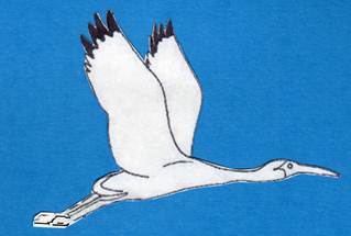
As mentioned in the post below, Friends of the Lower Suwannee & Cedar Keys NWRs provided support to tag Suwannee, a Swallow-tailed Kite that is now migrating from the Refuge to his wintering area in Brazil. Stories about the research and tracking of the migrating birds have recently been published by Audubon and bioGraphic. Each site has an interactive map that allows you to follow Suwannee's migration. The map will be updated weekly. Enjoy!
 Suwannee left the Refuge in early August to begin his migration. He is now in the Yucatan. Debbie Jordan, here. I am a member of the Friends Board of Directors. I am shepherding Friends' Swallow-tailed Kite Project. In the spring of this year, Friends provided funding to tag one Swallow-tailed Kite that was summering on the Refuge so it could be tracked during its migration to Brazil and back. Here is the background. Now, I have an update.
Stay tuned to the website for updates on his progress, as he makes his way to South America! We wish Suwannee and the other 15 birds of the Class of 2019 a safe migration with plenty to eat. Habitat loss along the flyways is a huge threat for migrating birds. Articles about kite research are anticipated this fall in the Audubon magazine and other publications. We will keep you posted as more info becomes available.
This graphic, from Refuge biologist Vic Doig, shows the hourly and accumulated precipitation at the Lower Suwannee Refuge over the past week, from August 12 to August 20.  Note from the webmaster: The comment below makes us want to clarify the post. The video is a time-lapse. It is 33 seconds long and was taken as the Deputy Refuge Manager drove a little over a mile of the road at about 3 miles per hour to assess the flooding. The video looks like the driver is zooming, which as the comments says, would severely damage the road surface. The flowing water, all by itself, caused erosion and damage to the road, which will be repaired when the flooding abates. Refuge Manager,Andrew Gude, provides his cell phone number at the upper right on our home page. You can call him for an update on the roads if you are thinking of heading to the Refuge. As of Monday August 26, none of the Refuge roads are open. Here is the original post: Don't try this at home. Driving on flooded roads, especially the limerock Refuge roads, is never wise. Even if you don't get stuck, ruts you cause in the soft roadbed have to be repaired. Refuge Asst. Manager Larry Woodward took this video when he assessed the extent of the flooded Nature Drive, giving us a rare look as if we were driving with him through the flooded Refuge.
Roads on the Refuge, on the Levy County side, are still closed as of August 22 due to flooding. County Road 347, from which one accesses the Refuge roads, was closed for several days. It reopened on Wednesday August 21.
Refuge staff members are monitoring the roads and other areas. Refuge Biologist, Vic Doig, reports that "The Refuge area received over 20" of rain between Aug 14 - Aug 18th, and much of the area is heavily flooded. The last time we saw nearly as much rain in a short period was during Hurricanes Francis and Jean in Sept 2004, when about 15" fell over a few days. All Refuge roads are currently closed, and even some adjacent highways are partially closed due to flooding. For comparison sake, our average annual rainfall is about 50" a year - we are already well above that with this recent event, and it is still August!! Let's all hope and pray for a dry hurricane season this year." When Refuge Manager Andrew Gude checked on the Nature Drive yesterday, he reported that "In a brief period of time I saw, in the same view, a gator laying in the road, a snake moving across it, gar swimming like salmon over the road, and an egret standing on the downside of the road nailing fish as they came over the road."
Friends of the Lower Suwannee and Cedar Keys National Wildlife Refuges is requesting proposals from duly licensed and qualified consultants or consulting teams to perform an assessment of several historic structures on the Vista site within the Lower Suwannee Refuge near Fowler’s Bluff, Florida. We are interested in using the Vista site for visitor contact and interpretation.
We have received a planning grant from the Florida Department of State Division of Historical Resources to conduct for the project. This project will provide documentation and information about the buildings at Vista, and hopefully, will be a planning tool for the maintenance, stabilization, preservation, and future rehabilitation of the structures. The full RFP is available here. New information indicates that Snake Key, in addition to all the other birds now roosting there, is a significant pre-migratory mass roosting site for Purple Martins. Folks in Cedar Key started seeing and reporting massive numbers of purple martins a couple years ago in the mid to late summer. The Refuge staff members worked with Dr. Jason Fletcher, a Disney Animal Kingdom researcher who tagged some of the birds. One was tracked to Snake Key after last breeding season. Further investigation by Dr. Fisher and Refuge biologist Vic Doig show that as many as 5,000 Purple Martins were roosting overnight at Snake Key in July.
 Photo by Friends member Ann Kamzelski The Friends of the Lower Suwannee & Cedar Keys NWRs is helping support the satellite tracking of a Swallow-tailed Kite as it migrates from the Refuge to Brazil.
Read more at Swallow-tailed Kite Migration: a ten thousand mile odyssey
George talked us through his expansive, inspiring vision of the Big Bend Conservation effort, with detailed data on its history and current status, on key land areas for needed conservation, on key players, and on the role that the Lower Suwannee and other Refuges could play in the effort to keep the Big Bend as a driver for the regional economy and quality of life.
George was a man who made a difference in all our lives, even those of us who never were lucky enough to meet him personally. Clay Henderson, a lawyer and professor at Stetson University, was quoted in Politico as saying that only Teddy Roosevelt conserved more land in Florida than George did. He was involved in about half a million acres of land deals. George's obituary can be found here.
During the January 2019 government shutdown, vandals defaced one of the Lower Suwannee Refuge's main directional signs. Friends members made temporary repairs. Finally, the permanent repair is in place. Thanks to the Friends members who kept all of us from having to live with the vandalism from January until July!  Thanks to Friends former president Maria Sgambati for forwarding this YouTube of swallow-tailed kites. And thanks to Raymond Powers for taking and posting the video! The birds were gathering on a farm near the Refuge in Gilchrist County in preparation for their migration. Friends is supporting the tracking of one swallow-tailed kite on its migration this year. Maybe ours is in this group! See the video here.  For Release on Monday, 15 July 2019
Lower Suwannee National Wildlife Refuge in Chiefland, Florida is Accepting Comments on Hunting Permit Fees …. The U.S. Fish and Wildlife Service’s Lower Suwannee National Wildlife Refuge (Refuge) is accepting public comments on increasing the yearly hunter access fee for hunting on the Refuge. The current fee is $15.00 and we are proposing a $10.00 increase to $25.00 for the 2020-2021 season. The recreational fees will be retained by the U.S. Fish and Wildlife Service as a part of the Recreational Fee Program and used for road maintenance as part of the administration of the hunting program. The Refuge maintains 194 miles of public driving and secondary grass road/trails accessible by walking or biking, providing public access to some of the most remote parts of the Refuge. Since 1981, the U.S. Fish and Wildlife Service has had authority to collect recreation fees. Since 1997, the Service has been able to retain fees collected at the station, first under the Recreation Fee Demonstration Program and then, in 2004, under the authority of Federal Lands Recreation Enhancement Act (FLREA). The FLREA was established to provide funding for recreation program improvements. Typical projects paid for by recreation fee funds include road and parking lot maintenance, brochures, envelopes, handling and mailings of hunt information, trail improvements, and salaries for law enforcement. A fee analysis has been done by Refuge staff and these fees are proposed based on what nearby entities and National Wildlife Refuges are requesting. The refuge is proposing to make these fee changes effective next year’s hunt season. We are interested in hearing from you regarding the proposed new fee requirement and are requesting public comments beginning 15 July through 15 August 2019. Please submit any comments by email ([email protected]; Subject Line: “Hunt Fee Comment”), phone (352.492.0238 x224), or mail (Hunt Fee Comments c/o Andrew Gude, 16450 NW 31st Place, Chiefland, FL 32626) on the proposed fee changes. The mission of the U.S. Fish and Wildlife Service is working with others to conserve, protect and enhance fish, wildlife and plants and their habitats for the continuing benefit of the American people. For more information on our work and the people who make it happen, visit www.fws.gov. Connect with us on the web at https://www.fws.gov/refuge/lower_suwannee/, our Friends of the Lower Suwannee National Wildlife Refuge website http://www.friendsofrefuges.org/, our Facebook pages at www.facebook.com/usfwssoutheast, watch our YouTube Channel at http://www.youtube.com/usfws and download photos from our Flickr page at http://www.flickr.com/photos/usfwssoutheast. Andrew G. Gude Office 352.493.0238 x224 | Cell 703.622.3896 U.S. Fish & Wildlife Service, National Wildlife Refuge System Lower Suwannee & Cedar Keys NWR: 16450 NW 31st. Place, Chiefland, Florida 32626
The Re-lighting Ceremony was a centerpiece in three days of Fourth of July Celebrations in Cedar Key. Despite a misty rain, music, residents, and visitors filled Second Street starting at 7 on Friday evening July 5th. The local merchants created a festive, convivial atmosphere for the red-white-and-blue wearing crowds. As dark was arriving, everyone gathered at G and First Street. Mayor Heather Davis harkened to the days when his grandfather used the Cedar Key Light Station to get home from sea. County Commissioner John Meeks pointed out that no one alive today has seen the light turned on, until those of us gathered do on this night. Refuge Manager Andrew Gude told us that our Nature Coast is the longest, darkest, most undeveloped coastline in the contiguous US. NCBS Director told us how we managed to get the funding to relight the Cedar Key Light Station on Seahorse Key National Wildlife Refuge. With the help of the Historical Society's Carol McQueen, the last woman to live at the Light Station, Catherine Hobday came to life and told her story. Anna Hodges executive director of the Cedar Key Historical Society led the "flash mob" in singing the Star Spangled Banner. At 9:30, Captain Kenny McCain and Refuge Deputy Manager Larry Woodward, out on Seahorse Key, flipped the switch and all of us on shore celebrated the lighting with sparklers and fireworks launched from boats in the channel. Read more in Cedar Key News.
Friends of the Lower Suwannee & Cedar Keys National Wildlife Refuges will be welcoming visitors to the beach during the Seahorse Key Open House from 9:00 to 3:00 on Saturday, July 6 and again on Saturday October 19. Be sure to hike up to the Light Station, cross over to its far side, and come down to the beach to say hello. The beach is a wondrous place. Volunteers at the Friends tent will answer your questions and you can walk along the beach to explore.  Seahorse Key with Cedar Key Light Station at the center, the harbor in front of it, and the beach on the far side Seahorse Key is one of the 13 islands that make up the Cedar Keys National Wildlife Refuge. The Refuge was established in 1929 to protect what may have been as many as 200,000 birds that came to Seahorse Key and the other islands for roosting, courting, and nesting. The protection was necessary at the time because massive numbers of birds had been killed in the 1800s for their plumage, which was used to make ladies' hats. Before the sudden abandonment of the Seahorse Key rookery in April 2017, there were still tens of thousands birds nesting there. Only a few have returned to Seahorse Key, but many birds have established a rookery on nearby, smaller Snake Key. It has almost reached its capacity.  Walking up to the Light Station Seahorse Key is the home of the Cedar Key Light Station, which will be open to visit during the Open House. Under a special use permit arrangement with the Refuge, the University of Florida manages about three acres of Seahorse Key, including the Light Station, for marine research. Visitors can also visit the research building during the Open House. There is no charge to attend the Open House once you get to the island. Access to Seahorse Key is available to the public through Tidewater Tours, Cedar Key Boat Rentals and Island Tours, or you can come in your private boat during the open houses which happen about four times a year.  Leaving Cedar Key behind you on the way to Seahorse Key |


Friends of the Lower Suwannee & Cedar Keys National Wildlife Refuges
P. O. Box 532 Cedar Key, FL 32625 [email protected] We are a 501(c)(3) nonprofit organization. |
|